Would you like to react to this message? Create an account in a few clicks or log in to continue.
Welcome to the Charlie Tango DX Group. The home of ALL things Radio - CB, 11m DX, Amateur, PMR446, PLD, Network and Data. We welcome all radio enthusiasts of all knowledge levels. Join today and claim your own unique World Famous CT Call-sign
Call Sign : 2E0VRX Posts : 776 Times Thanked : 47 Join date : 2019-06-27 QTH or Location : Yorkshire dales Equipment Used : Yaesu FTdx 101d, MD200 mic ,Mosley 3ele Yagi Age : 59
Subject: Expedition Safety and Preparation Sun Feb 09, 2020 12:30 pm
Various helpful articles for operating portable in extreme conditions and locations.Safety should always be paramount but becomes even more vital when taking to hills and mountains or when out in extreme conditions
Matt86 CT Directors
Call Sign : 26ct2767 Posts : 251 Times Thanked : 5 Join date : 2019-06-27 QTH or Location : Swindon Equipment Used : Yaesu ft818 , yaesu 8900r , yaesu ft950, stalker 9 Age : 38
Subject: Re: Expedition Safety and Preparation Mon Feb 24, 2020 10:31 pm
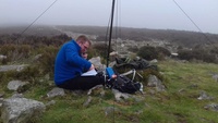
As a CTX and SOTA activator i always plan before for the activation ahead, be it a afternoon, a day, or a overnight .
Where are you planning to go activate ?
I always activate on public right of way land / bridleways / footpaths and not on private Land. Before hand speak to people who may have been up the location or pre plan a trip out if you can to suss the location out. Also Google maps is your friend with satalite a 3D view, i currently have a subscription to .S maps and can use it on my Android phone and my pc / laptop various views on there, i use 1:25 and 1:50 scale the most for when walking the route, Many other mapping software / apps are about also .
Inform family member or friend(s) to where you are going and when you expect to be there and getting home. If you can due to mobile phone coverage, make contact once you leave the car and return to the car. Also during the day if you can is better still . If there is a incident someone will know your rough location at a given time when you last had contact if they need to inform the relevant services. Also a great idea to give them a printout of the route your are walking along and where roughly the area id you will be setting up your station from .
GPS tacking ? I have used them in the past but i see myself using a mobile with my mapping App as already sugested and i find you can do more with phone apps than lower end to mid range GPS hanhelds . I also carry a OS map or a printout of the area i am in case modern technoligy is not useable to to signal.
Personal kit not including clothing i carry with me does not really change much on the longer activations and walks. First aid kit, a small kit i put together of a few essintials, even carry a insect bite pen, pain killers and a few saftey pins also come in usefull for other scenarios. Torch ( head torch ) or and a glow stick, just in case get caught out later than you think or happen to be stuck out while waiting for rescue. Bivvy / survival bag or a foil blanket, pack up really small and can get you out of the elements if waiting for rescue. I also carry a basha / DD tarp with a length or cord to able to errect a shelter with a walking pole or nearby trees. Water / water filter, depending on the length of time out i mormally take 2L of water plus my swayer mini filter and i have yet to be ill when using it but recomend flowing water. Energy snacks, energy drink additive or genral food depending how long you will be away from your vehicle .
Clothing , depending on the time of year just have to have a think and when you are up in the clouds on top of a mountain it can get cold even though was warm when you left the car at the bottom. As a guide to start with. Gloves, hat, thermals but i prefer merino wool t shirts and leggins as a base layer this time of year with a extra t shirt and a medium base layer and a outer waterprrof jacket / softshell . I am a warm tempeture person but others will take more or less. known in the summer to take a few extra layers even if just long sleeve t shirt and a extra mid layer for on top of the summit . Waterproofs, i take them with me regardless of forecast even if just a jacket as my summer trousers dry pretty quick in the sunshine. nice sturdy pair of walking boots or shoes that fit you well ! no point wearing ill fitting footwear, its not pleasant !
Future developments ?
I plan to start playing around with APRS as a tracking beacon and able to send brief text messages / spots when out walking / activating via the VHF 2m band as a licenced amateur it will be another tool in my kit for another mode of tracking / communication when mobile phones are not working , also it has been known with electronic equipment up high in cold conditions phones can stop working due to the tempeture .
Just a brief explination and my thoughts for some planning with saftey in mind .
73 , Matt
26TC62 Senior contributor
Call Sign : 26TC62, 26CT2817 Posts : 141 Times Thanked : 29 Join date : 2019-06-27 QTH or Location : Portsmouth Equipment Used : Yaesu 891, 10m pole, wire 5/8, T2LT
Subject: Re: Expedition Safety and Preparation Tue Feb 25, 2020 11:00 am
The OS map app is absolutely brilliant, I use it constantly. I find if I'm plotting a route the estimated time to walk it is generally very accurate for me personally which is another boon.
A couple of other useful sites for scouting out a location is www.geograph.org.uk - this is organised by OS square and has lots of useful photographs of sites. It is very useful when trying to work out what the surroundings on the ground are like in a given location, if there are trees for rigging a tarp, fence posts for antenna poles, and whether it is possible to set up in a way that works for you. These are details you often can't pick up from the satellite views.
Another one I use a lot is https://en-gb.topographic-map.com/maps/b9/England/ which gives you a good idea of how prominent a site is above the surrounding terrain and what the path is like towards a given part of the country.
Paddy likes this post
Matt86 CT Directors
Call Sign : 26ct2767 Posts : 251 Times Thanked : 5 Join date : 2019-06-27 QTH or Location : Swindon Equipment Used : Yaesu ft818 , yaesu 8900r , yaesu ft950, stalker 9 Age : 38
Subject: Re: Expedition Safety and Preparation Tue Feb 25, 2020 11:47 am
Thank you for your input , never come across that site I will check it out later.
Genrally I operate from SOTA summits and kill 2 birds with one stone, activate SOTA then onto CTX. I use SOTA mapping project website which gives you registered summits with activation reports and much needed info about the summit . A very handy website even just to look at even if not licenced or do not contribute to SOTA.
73 , Matt
pete_winkley New Member
Call Sign : 26-CTX-355 2E0PNW Posts : 15 Times Thanked : 2 Join date : 2022-10-09 QTH or Location : Radlett Hertfodshire Equipment Used : FT-891, Ft-818, EFHW, Inverted V Dip[ole Age : 39
Subject: Re: Expedition Safety and Preparation Thu Oct 27, 2022 12:40 pm
Morning,
I know this post is old at this point but I thought that I would add some info I think is useful for future reference.
Firstly some great info in Matt's post about kit etc in the mountains.
In Matt's post, he mentioned using APRS as a method of communication on the mountains. I just wanted to make people aware of a service called smsgte https://smsgte.org/. It is free to use service that relays APRS messages to SMS, allowing you to send a text even if you are out of mobile phone service. I have successfully used it to send a simple text from my radio. Obviously, to make full use of the service, you would need to have a radio with APRS messaging features. But in a pinch, you can use an APRS app for your phone, set to audio rather than internet relay, and simply key up on 144.800 whiles playing the audio from the phone. The disadvantage of this is that you can't receive a reply but it could enable contact from a summit with no service.